|
|
||||
|
|
IMPORTANT PLEASE READ This website and forum has been living on borrowed web server time for years. At the end of this month silsden.net in it's present form will cease to exist, BUT there is a new silsden.net in the making, and a new forum, and lots of exciting new things coming to this space. Peter |
 back
to General Forum | back to forum index | login
|
sign
up | help
| latest topics | search
back
to General Forum | back to forum index | login
|
sign
up | help
| latest topics | search
Replies in this thread : 11
Author |
Topic : Is there a footpath at the top of Banklands Lane. |
|
| midway |
Well as you can see on the map, because it has been restricted for a number of years, it is now not on the Definitive map.  |

|
| Peter |
This is part of the footpath map which used to hang in the council chambers (now the library) in the Town Hall. This map was referred to by Bradford as the definitive map of Silsden's footpaths. It clearly shows Hawber Cote Lane extending to the barn and joining up with the footpath which runs from Drabble Farm to the top of the allotments. 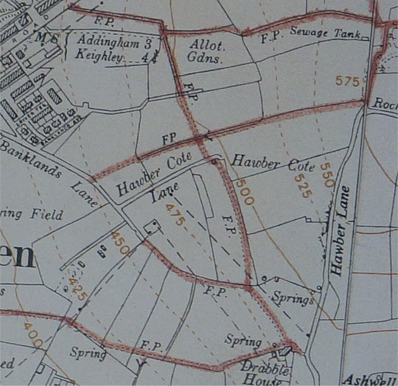 |

|
| midway |
Apologies, i should have been more specific, i meant to say Hawber Cote Lane. |

|
| Peter |
As you can see from the map, Hawber Cote Lane was open to the barn and led to the footpath which goes to the east of the barn, shown on the current footpath map. These days Hawber Cote Lane, on from where the hard surface ends, it is overgrown and there is barbed wire across. The line across on the current map is where the hard surface of the road finishes - this path should be reclaimed for the public to use. |

|
| midway |
Well we are getting nearer to it being open, the barbwire has been removed.  |

|
| midway |
this post has been edited 1 time(s) The photo shows the direction of the path, am i correct?  |

|
| Peter |
I know people climb over this fence and "think" there is a footpath from Hawber Cote Lane to the top of Hawber Cote Drive BUT.... ..it is just a short cut and NOT a recognised public footpath. Can you see a footpath on the FP map I posted or on the Braford FP map? Any dotted lines you see on the Bradford map are just shortcuts, the one which goes diagonally left across the field from the top of Hawber Cote Drive is a good example. The footpaths on the Bradford map are marked in purple. I believe Hawber Cote Lane to the barn should be open to the public where it would join the public footpath that runs north / south. At the moment Hawber Cote Lane is very overgrown (a lane with very overgrown hedges on both sides of the lane) and there is a farmer's fence and barbed wire across the lane. This a copy of a map published in 1853. The lane is open to Banklands Lane and would be available for the public to use. 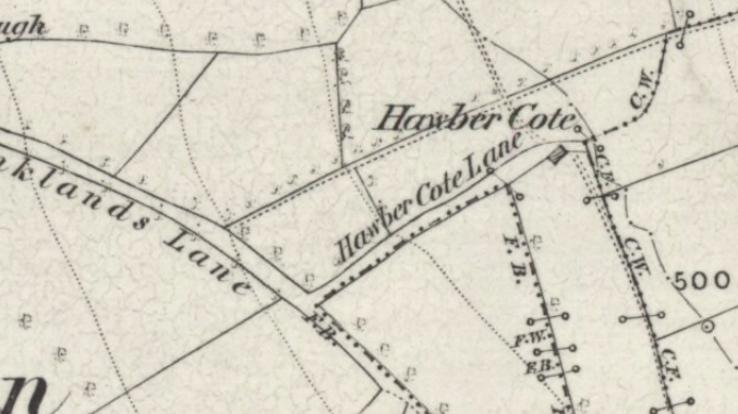 |

|
| midway |
Yes i think we've got it sorted, this photo shows what should be Hawber Cote Lane. now blocked with garden rubbish. and the style removed to make it impossible for anybody to use.  |

|
| midway |
And this is the other end of the lane.  |

|
| dogcatcher |
this post has been edited 1 time(s) cc |

|
| dogcatcher |
it certainly seems to av been blocked off for a very long time so is it needed,there seems to be enough paths round about. |

|
| midway |
A fair point Doggy, but it's possible we could loose the footpath in the photo below.  |

|
| Replies in this thread : 11 |
events sale / wanted general have your say looking for.. skippy greengrass |
||
DON'T FORGET THE SUBJECT IS >>>>>>>> Forums Home > General Forum > Is there a footpath at the top of Banklands Lane. |
|||
|
<< HOME PAGE < RETURN ^ PAGE TOP ^ | ||
|
webenquiries to |
||