|
|
||||
|
|
IMPORTANT PLEASE READ This website and forum has been living on borrowed web server time for years. At the end of this month silsden.net in it's present form will cease to exist, BUT there is a new silsden.net in the making, and a new forum, and lots of exciting new things coming to this space. Peter |
 back
to EVENTS - ANNOUNCEMENTS - MEETINGS | back to forum index | login
|
sign
up | help
| latest topics | search
back
to EVENTS - ANNOUNCEMENTS - MEETINGS | back to forum index | login
|
sign
up | help
| latest topics | search
Replies in this thread : 14
Author |
Topic : STC Agenda for Thursday 7th Jan 2016 - Flooding / planning |
|
| Peter |
STC Agenda for Thursday 7th Jan 2016 www.silsden.net/town_council/docs_16/16_meetings/STC_meeting_agenda_Jan2016.pdf Item 6 Flooding Item 9 Core Strategy Item 13 Planning 15/03871/MAF | Construction of 51 dwellings and internal access roads, landscaping, associated infrastructure and works including demolition of High Bank House (submission of amended plans) | Land At Sykes Lane Silsden West Yorkshire. To see this application / make a comment Go to planning.bradford.gov.uk/online-applications/ Then search using 15/03871/MAF |

|
| Peter |
TONIGHT |

|
| Peter |
THE FLOOD REPORT PRESENTED TO SILSDEN TOWN COUNCIL A report on where the water came from, where it went and the damage caused. news.silsden.net/wp-content/uploads/2016/01/Silsden_Floods_report_26_Dec_2015.pdf 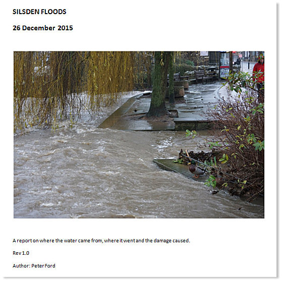 |

|
| ginjo |
well done peter an excellent report, do you know what the town council intend to do with it now? I am amazed that no repair work has been started yet on the damage down by Aldi or on the blocked drain at bottom of Mitchell lane and the piece of road that has sunk and cracked.Sureley it needs doing sooner rather than later.Was the escape route path from Aldi flooded because that looked to be covered in debris |

|
| Peter |
quotewell done peter an excellent report, do you know what the town council intend to do with it now? I am amazed that no repair work has been started yet on the damage down by Aldi or on the blocked drain at bottom of Mitchell lane and the piece of road that has sunk and cracked.Sureley it needs doing sooner rather than later.Was the escape route path from Aldi flooded because that looked to be covered in debris The blocked drain at the bottom of Mitchell Lane - Bradford have said they will repair it to working order ASAP. The area in St Johns Street which has a large expanding crack - is private land. I would suspect the repair of the wall by Aldi is a resource problem and it will be fixed ASAP. The Town Council will use the report to show Bradford where the flooding problems occur and will be setting up a meeting to hopefully sort things out for the future. They will also be looking at a local contingency plan with Bradford to cope with future flooding issue on a local level. They will be writing to the Environmental Agency and Yorkshire Water to see if the flow from the reservoir in times of flood can be made less. |

|
| Mickyfinn |
Peter, you say in your report that the line of sandbags at the top of St.John's Street, which is diverting floodwater from Mitchell Lane, should remain in place until the storm drain at the bottom of Mitchell Lane is repaired. Unfortunately there are drivers of vehicles who find these sandbags to be a nuisance & probably wonder why they are still in place now the flooding has ceased. Sandbags have been driven over or have been moved out of the way. With regard to the landslip on Airedale Factor's land, surely, at some point, this area will give way completely & if we get more flooding there must be a risk of the beck bank being undermined. Is there no way the landowner can be compelled to made good the site? |

|
| ginjo |
firstly, did the town council ask you to do this peter, because it is something which they should have done really, anyway whatever, you did a good job.Regarding the collapsed road near the beck,do you know whether the council have spoken to the landowner, I suppose its possible that he will be holding the council responsible for not repairing the drain at bottom of Mitchell lane, meanwhile nothing gets sorted. |

|
| gazzer |
quotePeter, you say in your report that the line of sandbags at the top of St.John's Street, which is diverting floodwater from Mitchell Lane, should remain in place until the storm drain at the bottom of Mitchell Lane is repaired. Unfortunately there are drivers of vehicles who find these sandbags to be a nuisance & probably wonder why they are still in place now the flooding has ceased. Sandbags have been driven over or have been moved out of the way. With regard to the landslip on Airedale Factor's land, surely, at some point, this area will give way completely & if we get more flooding there must be a risk of the beck bank being undermined. Is there no way the landowner can be compelled to made good the site? Do I remember correctly, although maybe not in this recent flood, that the drains on Howden Road being unable to cope with run off causing flooding at the junction of Howden Road and St John St. If so it should be included in any submissions to Bradford Council. The Town Council should ask Bradford Council for copies of reports they have legally to publish regarding flooding in the last 20 years or so. |

|
| Peter |
I take lots of pictures to document events in Silsden. The pictures I took on 26 Dec was a way of putting to rest the arguments which have been going on about the reason for flooding on St Johns Street and photographic evidence to allow things to be sorted out for the future. It seemed a shame to just put the pictures on the website so I also wrote the report. I was not commissioned or asked to do this. Re the sandbags at the top of St Johns Street, I'm sure the sandbags at the end could be moved closer to the beck wall for now. The sandbags which cover the parking area could be left where they are. The flood risk is not over. The field are still very wet and it will not take that much prolonged rain for the flooding to occur again. As I understand it STC will be investigating a curved gully to be fitted where the sandbags are, this will be a permanent overflow solution which can be driven over. Re the car parking area subsidence on St Johns Street - this is private land and I guess the onus is on the landowner to repair it. The area is cordoned off as a safety measure... KEEP AWAY. One thing I would like to point out - when I was walking round some of the roads (like Mitchell Lane) had water running over the surface, it didn't look much and it was difficult to photograph. However, when this water reached it's destination, in this case St Johns Street, it was channelled and it was a significant amount. You can see how much on the picture of the water pouring through the hole in the beck wall. |

|
| Mickyfinn |
Peter, it is rather intriguing where water goes from the two gullies at the top of Mitchell Lane. We used to suffer from a yard full of surface water whenever we got rain at our property in St.John's Street. After years of chasing Bradford Council it was discovered that a gulley on the opposite side of the street discharged via a pipe across the street into an ancient culvert which discharged the water into the beck. Unfortunately someone had blocked the culvert with a concrete plug. Now sorted to our great relief. |

|
| gazzer |
quotePeter, it is rather intriguing where water goes from the two gullies at the top of Mitchell Lane. We used to suffer from a yard full of surface water whenever we got rain at our property in St.John's Street. After years of chasing Bradford Council it was discovered that a gulley on the opposite side of the street discharged via a pipe across the street into an ancient culvert which discharged the water into the beck. Unfortunately someone had blocked the culvert with a concrete plug. Now sorted to our great relief. I could maybe get some drain tracing dye |

|
| Mickyfinn |
Gazzer, at the bottom of Howden Road/St.John's Street there is a distinctive 'hump' in the road as it turns into Clog Bridge. This 'hump' has the tendency to make surface water running down Howden Road & St.John's Street accumulate as it meets up with this obstructive 'hump' & consequently causes flooding in the area at the bottom of St.John's Street, on occasions quite extensively. Has this 'hump' in the road always been there, or was it artificially created when Clog Bridge was built. In the old days, flood water would have come down St.John's Street & Coal Pit Lane & flood water would have gone down to 'Jumping Jack' & taken away. If this 'hump' in the road were to be removed & a storm drain built at the bottom of these two roads would this result in the draining of flood water Apparently, this hump in the road, it would seem was not considered to be a problem when Clog Bridge was built. |

|
| gazzer |
this post has been edited 1 time(s) quoteHas this 'hump' in the road always been there, or was it artificially created when Clog Bridge was built. Do you know where Sam Throupe lives?. His front path is level with the footpath on the street.Before the new bridge was built it stepped down to the road(there was no footpath) about 7 or 8". I think there always was a hump but maybe not as much. If you stood with your back to the lamp post outside Waterloo Mill and facing St John Street.Then take 6 paces to your left still facing St John St.Then step forward until you are in the middle of the raised sets.You would then be stood at what was the lowest point but you would also be stood on a road gulley. |

|
| gazzer |
quoteGazzer, at the bottom of Howden Road/St.John's Street there is a distinctive 'hump' in the road as it turns into Clog Bridge. This 'hump' has the tendency to make surface water running down Howden Road & St.John's Street accumulate as it meets up with this obstructive 'hump' & consequently causes flooding in the area at the bottom of St.John's Street, on occasions quite extensively. Has this 'hump' in the road always been there, or was it artificially created when Clog Bridge was built. You can see the road gulley in front of the house, then the road begins to rise.You can see the gradient if you follow the stone course's on the front mill yard wall  |

|
| gazzer |
Here you can see the path from the house on the left has a step down to road, but today it finishes level meaning that part of Clog Bridge was raised  |

|
| Replies in this thread : 14 |
events sale / wanted general have your say looking for.. skippy greengrass |
||
DON'T FORGET THE SUBJECT IS >>>>>>>> Forums Home > EVENTS - ANNOUNCEMENTS - MEETINGS > STC Agenda for Thursday 7th Jan 2016 - Flooding / planning |
|||
|
<< HOME PAGE < RETURN ^ PAGE TOP ^ | ||
|
webenquiries to |
||