|
|
||||
|
|
IMPORTANT PLEASE READ This website and forum has been living on borrowed web server time for years. At the end of this month silsden.net in it's present form will cease to exist, BUT there is a new silsden.net in the making, and a new forum, and lots of exciting new things coming to this space. Peter |
 back
to General Forum | back to forum index | login
|
sign
up | help
| latest topics | search
back
to General Forum | back to forum index | login
|
sign
up | help
| latest topics | search
Replies in this thread : 27
Author |
Topic : Works at tannery corner? |
|
| hat |
Anyone know whats happening at the top of north street/ tannery corner? The road has been shut and it looks like they are installing a pavement across the end of north street. |

|
| Peter |
this post has been edited 1 time(s) Bradford seem to have given up putting information on www.roadworks.org There is nothing for Tannery Corner and there was nothing for the dip in the road (outside the Kings Arms) for last week's work. Perhaps they have adopted a mushroom philosophy  |

|
| midway |
Looks to me the sight line is being improved, also diverting water running from Brownbank Lane. they wouldn't normally have a curb edge across a junction.  |

|
| midway |
This one shows the height of the edging.  |

|
| Peter |
See page 9 news.silsden.net/wp-content/uploads/2016/01/Silsden_Floods_report_26_Dec_2015.pdf ... and lots of pictures news.silsden.net/pictures/silsden-floods-boxing-day-2015 |

|
| hat |
the height of the kerb thats been pit in wouldnt stop that lot |

|
| midway |
Good report, Thank you Peter. Although i do notice you don't come to any conclusions has to why the water in the beck had two definite increases in height during the flood. |

|
| Peter |
My report was on what I saw. A few hours earlier the beck was much higher, high enough to lift a large log onto the top of the Belton Road culvert. 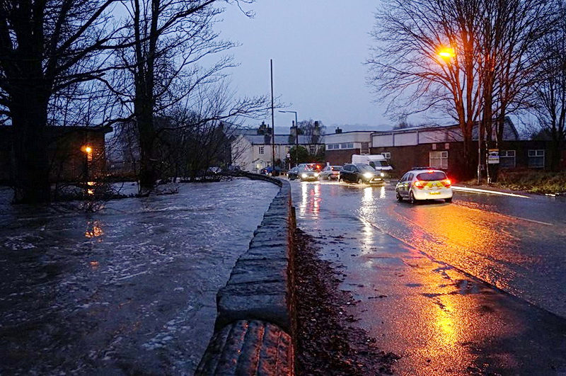 This is dangerous stuff... they want to build houses on the land south of Belton Road and on Banklands. Would you want a house on the Belton Road land? and Banklands retains masses of water, as any dog walker that walks the fields will confirm, and when they build on it will all end up in the beck, but much quicker than it does at the moment. They should be planting trees NOT houses. |

|
| midway |
Peter your last picture, why have we not seen it before, it clearly shows the danger those houses are in. |

|
| Peter |
I captured the picture from a Facebook post at the time of the flood, ie I didn't take it and I don't know who did. |

|
| OcusPocus |
Hi Peter, This is my picture you must have grabbed it from the Buzz page or similar, i have lots more taken at the same time and same location if you're interested i can email you some to use as you wish. |

|
| midway |
Any more photos as good as this OcusPocus I'd love a copy please. [email protected] |

|
| Peter |
quoteHi Peter, This is my picture you must have grabbed it from the Buzz page or similar, i have lots more taken at the same time and same location if you're interested i can email you some to use as you wish. Yes please, and if I could share them permanently on the website (with credits to you) that would be great. I waited until it had got light before I went out to take pictures that morning and it was obvious from the damage and the log on top of the culvert it had been much higher. As it was I started at about 8.30am and didn't get back until lunchtime. (I have the other 3 you posted on Buzz. [email protected]) BTW at the planning approval meeting for the Belton Road houses; the man from Barratt Homes said Belton Road does not flood and the culvert was of sufficient capacity to cope with the beck in flood..... |

|
| HurricaneHector |
If you go and stand at the same spot the last photo was taken now you will see that a dam has been built across the beck at road level! So where will all that water have to go next time? |

|
| midway |
That's a fantastic shot. thank you OcusPocus.  |

|
| Peter |
this post has been edited 1 time(s) quote If you go and stand at the same spot the last photo was taken now you will see that a dam has been built across the beck at road level! So where will all that water have to go next time? It is not a dam but a bridge, but if the water is as high as the picture above it will divert some of the flood water around the back of Marsel House and onto Belton Road. It will then probably go across the road and pool in the dip - or go straight across the road and down the main entrance to the Barratt Homes development. 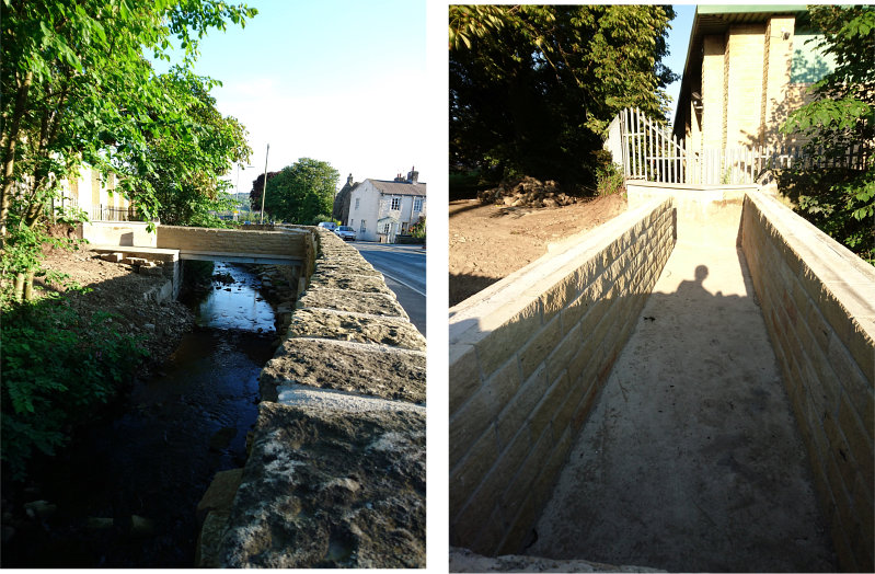 X-ref: www.silsden.net/forum/philboard_read.asp?id=9145 |

|
| midway |
Retrospective planning application for replacement of existing access bridge. at https://www.bradford.gov.uk/planning-and-building-control/planning-applications/view-planning-applications/ then enter 17/04028/FUL |

|
| grandad |
How can anybody call this a bridge, when there is no way to get onto it from one end? I.E. Keighley rd end. |

|
| Peter |
If you look very carefully there is a gap on the LHS to let the water into the trough, this will then form a barrier to water higher than the bottom of the bridge, this will divert the excess water around the back of Marsel House. The (retrospective) planning permission was for a replace bridge, which was approved. |

|
| Peter |
While we are at it, why is there a large hole built into the new wall. I know there was a hole there before the rebuild but shouldn't there be a metal plate on the inside of the wall? |

|
| dogcatcher |
i thought this thread was, WORKS AT TANNERY CORNER,OR IS IT A CERTAIN FEW THAT GET TOLD OFF FOR GOING OFF THREAD.??? |

|
| midway |
Keep up Doggy. the common thread within this topic is the height of flood defences. read all and be enlightened. |

|
| Peter |
quotei thought this thread was, WORKS AT TANNERY CORNER,OR IS IT A CERTAIN FEW THAT GET TOLD OFF FOR GOING OFF THREAD.??? You are quite correct BUT we seem to have exhausted that bit fairly quickly and really it's just a case of waiting to see exactly what Bradford are doing - they don't seem to want to tell us why! In the meantime one thing leads to another and we seemed to have moved on to flood defences. |

|
| midway |
this post has been edited 1 time(s) Is this flooding from the Beck or water flowing down North st.  |

|
| Peter |
this post has been edited 1 time(s) Thanks for changing the picture Middy |

|
| OcusPocus |
The water in this photo was coming down north street from Pickard Lane, arriving at Pickard Lane from the rear of Bolton Road, which started its journey from the top of North Street !!! the Tannery corner which is what this thread is about,on its journey it did severe damage to the rear of Bolton Road. |

|
| grandad |
Re my post above, bridge Meaning in the Cambridge English Dictionary https://dictionary.cambridge.org/dictionary/english/bridge bridge meaning, definition, what is bridge: a structure that is built over a river, road, or railway to allow people and vehicles to cross . Learn more. Dictionnaire Anglais · Suspension bridge · Rope bridge · Humpback bridge How can Bradford have allowed the structure to be approved? It is not a bridge, it is blocked off at the Keighley road end. |

|
| Peter |
The finished roadworks. The kerb should be just about high enough to keep the rain water going around the corner and down Bolton Road. 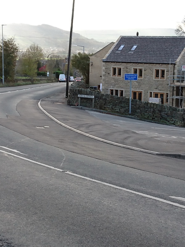 |

|
| Replies in this thread : 27 |
events sale / wanted general have your say looking for.. skippy greengrass |
||
DON'T FORGET THE SUBJECT IS >>>>>>>> Forums Home > General Forum > Works at tannery corner? |
|||
|
<< HOME PAGE < RETURN ^ PAGE TOP ^ | ||
|
webenquiries to |
||