|
|
||||
|
|
IMPORTANT PLEASE READ This website and forum has been living on borrowed web server time for years. At the end of this month silsden.net in it's present form will cease to exist, BUT there is a new silsden.net in the making, and a new forum, and lots of exciting new things coming to this space. Peter |
 back
to General Forum | back to forum index | login
|
sign
up | help
| latest topics | search
back
to General Forum | back to forum index | login
|
sign
up | help
| latest topics | search
Replies in this thread : 9
Author |
Topic : Gasometer near canal |
|
| Happysnapper |
Anyone able to tell me when the gasometer at the gasworks was removed ? Also anyone have any pics of that area that they could share |

|
| Peter |
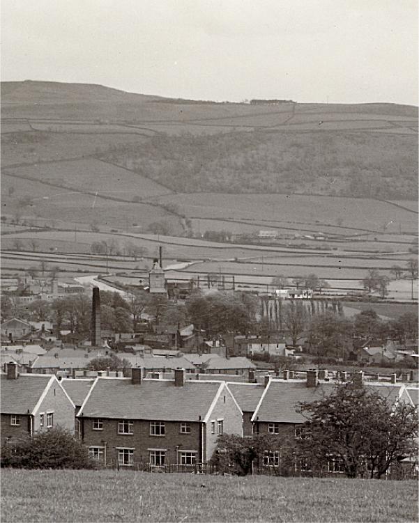 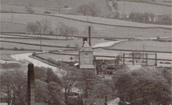 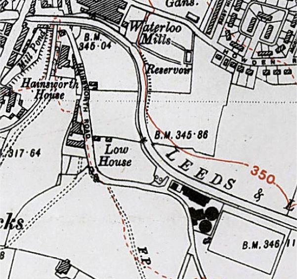 The map is the 1938 OS map which you can find on the website here www.silsden.net/useful/silsdenmap_1938.htm |

|
| Happysnapper |
Cheers for that Peter. Are they taken from top of Skipton road. I am very interested if anyone has any more pics of that stretch of the canal before waterside was built |

|
| steve |
Hi I have video footage of most of Silsden in 1989, this incluces from Jacksons bridge all the way past Brunthwaite bridge the non of the feilds under the culvert were built on then and the gas works is on the video, it is a very clear video, I have lots more of silsden, for example up howden road when wilsons mill was still there. |

|
| Happysnapper |
Would be very interested in watching that if possible. Is it on VHS or DVD format. I have gear to convert if needed. I am also interested what was opposite the gassworks. In the pic kindly provided by Peter it looks like some sort of factory or mill. |

|
| pgp001 |
this post has been edited 1 time(s) Peter/Steve Do you have any images form Howden Road taken during the period between 1938 and 1977. I have been told that there was a road called Green Lane where the bungalow is now built on the opposite side to the end of Jacques Grove. Also that there was some form of gatehouse at the end of that road as it led into military buildings where the canal side estate is now. Any info would be much appreciated. Thanks |

|
| old_miner |
I remember looking at a 1:25000 OS map from the 1950s. Must have been at a book fair and over priced otherwise I would have bought it. Anyhow, where Ings road is now there was a whole row of 'H' blocks which I suspect the small industrial unit is the last survivor. I assume this was a military camp and latterly for Ukranian refugees judging by the plaque on Ings road. |

|
| Peter |
quoteHi I have video footage of most of Silsden in 1989, this incluces from Jacksons bridge all the way past Brunthwaite bridge the non of the feilds under the culvert were built on then and the gas works is on the video, it is a very clear video, I have lots more of silsden, for example up howden road when wilsons mill was still there. Steve, there is a home for your video on this website if it can be converted. |

|
| old_miner |
Did Silsden ever have its own electricity generating plant? Never heard about it so I assume not, but anyone know the history of electricity in Silsden? |

|
| Happysnapper |
Hey steve ! any chance we can see this video footage please ? Would be a nice bit of lacal history |

|
| Replies in this thread : 9 |
events sale / wanted general have your say looking for.. skippy greengrass |
||
DON'T FORGET THE SUBJECT IS >>>>>>>> Forums Home > General Forum > Gasometer near canal |
|||
|
<< HOME PAGE < RETURN ^ PAGE TOP ^ | ||
|
webenquiries to |
||